Monday, September 30, 2019

Titanic April 1912

‘Stern View, Titanic’ from the famous Father Browne Collection of Titanic images. Taken while the ship is anchored at the entrance to Cork harbour, passengers can be seen relaxing on the after deck. A closer inspection of the after funnel reveals the image of a man’s head taking advantage of the spectacular views from his lofty position above the ship. Three and a half days after this nostalgic image was snapped, many of those passengers would have witnessed great tragedy and many would have been lost in the icy waters of the North Atlantic.
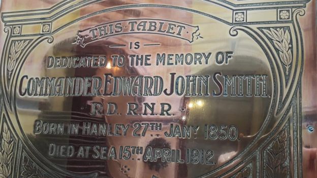
Titanic's captain, Edward John Smith, was born in Well Street in Hanley in 1850. The son of a pottery presser and a grocer, Smith attended Etruria British School before starting work at age 12 at the Etruria Forge, where he operated a steam hammer.
A few years later, he went to Liverpool to follow in the footsteps of his half-brother Joseph, who was in the Merchant Navy, and was apprenticed as an ordinary sailor. By the age of 25 he had passed his master's certificate of competency to command a vessel and by 1880 had joined the White Star Line where he rose through the ranks to captain some of the biggest ships of the day.
He married Sarah Eleanor Pennington, a farmer's daughter, in 1887, and their only child, Helen Melville Smith, was born in 1898.
Smith told a New York Times reporter in 1907 he had "never experienced any problems at sea". That same year, White Star revealed plans to build three new ships - the Olympic, the Titanic and the Gigantic. The Olympic went into service in 1911 and was captained by Smith, who now held the rank of commander.
By this point, he had become known as the "millionaire's captain", the number one choice for the aristocrats of the time - many of whom chose to sail with him because of his reputation for safety and affability.

The plaque
Image captionA plaque to Smith was installed at Hanley Town Hall

In April 1912, while the Olympic was in for repairs, he took command of the supposedly "unsinkable" RMS Titanic for its maiden transatlantic voyage from Southampton to New York. When it departed, the ship was carrying 885 crew members and 1,316 passengers.
Smith was awoken about 20 minutes before midnight on 14 April after the ship hit an iceberg.
The liner sank less than three hours later at about 02:20. About 1,500 people perished, including Smith who went down with his ship.
A number of different accounts emerged about what the captain's last movements were, with one version that he dived into the sea as the bridge of the ship went under.
The British inquiry into what happened found that Smith had ordered the ship to travel too fast and that the lifeboats had not been filled before being lowered, but it was made clear that "negligence cannot be said to have had any part".
Smith's portrait was hung in his former school in 1913 and later a plaque was installed in Hanley Town Hall, while a further plaque was installed at his former home in 2012 to mark 100 years since the ship's sinking.
A bronze statue of him stands in Lichfield's Beacon Park in south Staffordshire.
..........................................
Ancestry: The Titanic Collection for Family Historians

Halifax, Nova Scotia, Canada, RMS Titanic Fatality Reports, 1912
Halifax, Nova Scotia, Canada, RMS Titanic Graves, 1912
Titanic Survivors, Carpathia Passenger List, 1912
UK, RMS Titanic, Crew Records, 1912
UK, RMS Titanic, Deaths at Sea, 1912
UK, RMS Titanic, Outward Passenger List, 1912

molegenealogy.blogspot.co.za/2012/04/titanic-records-online.html

Friday, September 27, 2019

Diaz Point Lighthouse, Namibia

Diaz Point Lighthouse, Luderitz, Namibia, in 1979 is named after Bartholomew Diaz, the Portuguese Captain who took shelter in the bay and was the first to sail around the Cape of Good Hope in 1487-1488. 

The lighthouse is 28 m high with a lantern and gallery set on a one-story-high hexagonal stone base. Originally grey, the tower is now painted in red and white bands. The foghorn is 450 m north of the lighthouse.

The violent south-west winds which rage almost incessantly at Diaz Point drive sand with such force that one dare not venture outside without adequate protection. 

The lighthouse serves as a marking point for the Luderitz harbour and is a welcome sight to the mariner navigating along this inhospitable coast.

The one-time German colonial authorities of the area put up their own lighthouse ca 1903 not far from the site of the present lighthouse and both beacons were functioning from 1 October 1910 to March 1911. However it is the second, i.e. the current, lighthouse which is in operation today. Never a popular station, with its remote isolation and harsh environment, together with high cost of provisions and other supplies, a tour of duty there has been an unattractive post. But it had to be manned and a number of stalwart lightkeepers have carried out their duties there.

See more on the keepers' experiences at molegenealogy.blogspot.com/2015/08/last-of-south-african-lighthouse.html or use the blog's search facility using search term Diaz Point.


Tuesday, September 24, 2019

Dassen Island Lighthouse 2


Dassen Island with its Jackass Penguin Colony, now much reduced.
Dassen Island became notorious for the number of shipwrecks occurring in its vicinity. 
The Western seaward side of the coast is deadly, with high seas beating in from the Atlantic and consequently many ships being driven onto the rocks.

Dassen Island is a 200-acre barren rock and scrub, 55 kms north of Cape Town and 11 kms from the coast. The island and its partly submerged reefs was a menace to shipping which is compelled to approach the south-western Cape coast on its way to or from Table Bay. The low-lying islet brought disaster to more than one fine vessel, among them the first Windsor Castle on 19 October 1876. All those on board were rescued from the island.

The lighthouse commission presented a report to the government stressing the necessity of having a powerful light on Dassen Island without delay. The government was in agreement and parliament provided the necessary funds. In August 1891 the tender of Chance Bros of Birmingham was accepted: the company would supply an eighty-foot cast-iron tower, a 12-foot lantern and 920 mm dioptric apparatus, together with all spares, stores etc. The contract sum was 6, 700 pounds and delivery was to be made within twelve months.

Prior to the wreck of the SS Wallarah, Dassen Island was without a lighthouse. Whilst outward bound on her maiden voyage from London to Sydney in 1891, the SS Wallarah, commanded by Captain F.H. Ekins, and belonging to Wilhelm Lund’s celebrated Blue Anchor Line, was wrecked at Boom Point on Dassen Island. It was this loss which prompted the authorities to take action and the lighthouse was duly erected.

See waratahrevisited.blogspot.com/2016/08/loss-of-ss-wallarah.html


SS Wallarah was wrecked 1891 at Dassen Island. This photo shows her sister ship, Yarrawonga (1891, 4000 tons). 

Sunday, September 22, 2019

Dassen Island Lighthouse 1


Dassen Island Lighthouse is on the southern point of Dassen Island, west of Yzerfontein. It is a white circular cast-iron tower that has been in use since 1893.
The lighthouse is found on southern point of Dassen Island, off the western coast of South Africa, 55 km north-west of Cape Town and 11 km west of Ysterfontein. It was installed on 15 April 1893. The lighthouse consists of a circular cast-iron tower that is painted with white and red bands and stands atop a brick base to height of 28 m.


The light house signals two white flashes, separated by 10 s, every 30 s. The fog horn blasts for five seconds every fifteen seconds. The lighthouse is manned at all times. 

Dassen Island is the most isolated manned lighthouse on the South African seaboard. Set on a  barren outcrop of rock and sand some 55 km from Cape Town, and 11 km from the coast, the 28 metre high, circular lighthouse with its distinctive white and red bands is manned by a solitary senior lightkeeper.

It remains one of the major beacons on the Cape shipping route. In fact the island derives its name from the prevalence of shipwrecks in the area. It was so notorious that rabbits (dassies) and tortoises were released onto the island to serve as a source of food for any survivors.

The tower's outer walls are painted in eight alternative horizontal bands of red and white, whilst its lantern is twelve feet in diameter, the light of which was initially commissioned in April 1893. Today the range of the light is 24 sea miles so that on a clear evening one can see it from the top of Signal Hill in Cape Town.


Monday, September 16, 2019

Hamilton/Dixon-Smith


Eleanor Anne Dixon-Smith (nee Hamilton) b 16 September 1945, Durban, 
Natal, South Africa with her children, Andrew and Elizabeth.

Saturday, September 14, 2019

Gibson, Annie, widow, to Quebec from Scotland 18 June 1925


Passenger No. 2793 on the ship Letitia is Annie Gibson nee Bell, widow of Finlay Gibson (died December 1924). Annie was travelling to her daughter and son-in-law, the Robsons. She was to share a home with them in Winnipeg until her
death in September 1926.

Information included on this passenger list is her last address in the UK, 'Hawthorne, Stevenston, Ayrshire.' Her age is given as 66. Born on 14 February 1859 in Ontario, Annie was returning home after her years spent in Stevenston where she and Finlay had had 5 children - another Annie Gibson, Catherine Bell Gibson, Mary Gibson, Margaret Gibson and William Finlay Gibson, their only son, who died aged 22 in 1911. He was an engine fitter. Cause of death: lung disease.

At New Street Cemetery, Stevenston, is the memorial inscription
to William Gibson, son of Finlay and Annie, (age at death given as 23 here); his father's inscription reads Finlay Gibson died 31st December 1924 aged 84, and there is mention of Annie Bell, wife of Finlay Gibson died 27th Sept 1925 in Winnipeg Canada, 'where her remains rest'.


Annie Gibson lived here, 197 Hill Street, Norwood, Winnipeg, with her daughter (Kate) and son-in-law, the Robsons, after her return to Canada following the death of her husband Finlay Gibson.

Annie lies buried in Elmwood Cemetery, Winniepeg.

NOTE:
The Manitoba Free Press, Wed, 29 Sept 1926 p 7 col 3 'Deaths & funerals':

'Mrs Annie Gibson, widow of the late Finlay Gibson, died at St Boniface hospital on Monday. A native of Hamilton Ont she had spent most of her life in Scotland and had resided with her daughter, Mrs William Robson, 197 Hill Street, Norwood, about a year. The funeral will be held at 2 o'clock this afternoon from the Gardiner funeral home to Elmwood cemetery and Rev J E Ramsden will officiate'.

This announcement and the following were received from Denise Neufeld in Canada who also arranged for photos to be taken of the Robson house at 197 Hill Street. 

The Winnipeg Evening Tribune, Wed, 29 Sept, 1926, p 15 col 3 'Deaths':

'GIBSON - Entered late rest on Sept 27 at St Boniface Hospital, Annie Gibson, aged 67 years, widow of the late Finlay Gibson and mother of Mrs Wm. Robson 197 Hill Street ...(illeg) p.m. Wednesday, from the ... (A B? illeg) Gardiner Funeral Home, 172 Kennedy St. Interment in the family plot* at Elmwood Cemetery.'

Acknowledgements: Denise Newfeld

Monday, September 9, 2019

Cape Columbine Lighthouse, Paternoster, West Coast, South Africa


CAPE COLUMBINE LIGHTHOUSE  

Paternoster, West Coast, South Africa
Latitude   32° 49’ 39” S      Longitude   17 ° 51’ 23” E
Senior Lighthouse Keeper - Japie Greeff
Lighthouse Official - Wayne Brown

Standing on the ship’s bridge with the consistent rise and fall of the ocean swell, one looks landward and sees a windswept headland. This massive granite boulder is Castle Rock and, clinging like a limpet on the rock, stands the comforting sight of the uniquely-designed Cape Columbine Lighthouse, commanding sweeping views across the Atlantic Ocean.  For those on the bridge of a ship, or a sailor at the helm of his fishing boat or yacht, this tall, buttressed tower and powerful light, provides a dependable guardian for this treacherous section of coastline.

The Cape Times edition of 5 October 1936, reported,

There is no part of the South African coastline more dreaded by mariners than the uncertainties of Paternoster, for there are more hidden dangers than at any other locality. Heavy gales and a dangerous and confused sea are encountered through many months in the year and when the wind is not blowing, a fog obscures the whole coastline.’  

I recently had the great pleasure of meeting both Japie Greeff and Wayne Brown in the lighthouse on Castle Rock.  Japie, a man of strong character and integrity, proud and serious, is totally committed to duty, yet with a delightful sense of humour.  Having been a dedicated Lighthouse Keeper for the past 40 years and one of the last to man a light, Japie has made a substantial contribution by providing safety to yachts, fishermen and ships.  The light has guided them with their precious cargoes, passengers and crew when navigating the long, rugged and often extremely dangerous South African coastline.

Reflected in his face were his many proud years of endurance and resolve. The harsh realities of isolation and loneliness, danger and wild weather, and on occasion, shipwrecks and loss of lives, tests one’s courage and strength of character.

Japie entered the Lighthouse Service on 2 July 1979 at Diaz Point Lighthouse, Lüderitz, Namibia. In subsequent years, he was stationed at Dassen Island, Cape Recife, Cape Point and Pelican Point and took charge as Senior Lighthouse Keeper at Green Point Natal, Cape St Lucia and Cape Columbine. Some of these stations were very isolated and, essential to all Lighthouse Keepers, was the support of family and colleagues, with occasional visits from friends. Keeping constant vigil, exposing him to many unexpected and different situations, his duties would have ensured the searching beams of the lighthouses uninterruptedly swept out across the sea, guiding mariners along their coastal routes.

After chatting with Japie, he introduced us to Wayne, his Lighthouse Assistant, who had been his colleague for many years.  Of interest too, in the visitor reception, were the glass-fronted cabinets displaying Japie’s model aircraft, which had been assembled and painted as a hobby during the free hours in his days.  Our party, including my husband and his cousin, was privileged to be taken on a tour of the immaculately kept and lovingly cared-for interior of the tower.  Everywhere exuded a pride in presentation.

Japie led the way into an inclined passageway of highly polished, wide, green, stairs, connecting the Lighthouse reception room/shop to the foot of the Lighthouse.  The ceiling was gleaming; varnished wood and the side walls were hung with numerous identically-framed photos of various South African Lighthouses. As an aside, Cape Columbine Lighthouse (80m above sea level) was designed by H.C. Cooper, who also designed Cooper Light on the Bluff in Durban (137m). 

Our first stop was the foghorn compressor room with the original equipment which, unfortunately is no longer operational, but still enjoys attention shown in the immaculately maintained paintwork.  A modern electrical foghorn is erected on a large tower a short distance from the lighthouse. An Automatic Identification System (AIS), a tracking system for identifying and locating vessels by electronically exchanging data, is installed in the tower, making this the first Lighthouse to have had all three technologies – light, foghorn and AIS - installed during construction. The foghorn is a critical safety component when the dense West Coast fog rolls in. For those sailors finding themselves enclosed by this all-enveloping fog, the regular, haunting sound of the foghorn will guide them away from the dangers of the shoreline. One appreciates that this warning will have saved many lives along this coastline. Thinking of the past, we remember the drowned sailors and unfortunate castaways whose ghosts may still wander the coastline.

The first two levels in the lighthouse are accessed by steep, narrow wooden ladders with no handrails and a trapdoor set into each floor.  As we climbed step-by-step, we were following what each Keeper had been doing day-after-day, whilst going about their duties since October 1936. 

At the second level, we continued our climb up the short, steel, spiral staircase into the lantern room where highly polished brass fittings gleamed and the sun’s ray’s refracted rainbows of colour within the multi-layered Fresnel lens. Gone were the days when the Keeper had to polish the many individual lenses regularly, after being coated with black soot from the burning oil.  Today, the brilliance of the lens, so devotedly cared for, scattered light from the sunbeams streaming through the windows of the lantern room.

At an elevation of 80m above sea level, we had an exceptional and expansive view across the Atlantic Ocean to the clear line of the horizon. One wanted time to stand still as the captivating aura of the lighthouse set high above the ominous black shoreline rocks below, contrasted with the picturesque miles-long white beach as well as the stark inland landscape.  Our imagination took us to the months ahead, when the semi-desert dunes would be transformed by the seasonal blossoming of the desert flowers, transforming this dramatic landscape into a colourful pageant of flowers.

Thank you Japie for a most memorable experience.
Suzanne-Jo Leff Patterson

Footnote:
SV Columbine the British wooden sailing ship launched in 1824, was on a voyage from London to the new British colony of Sydney, New South Wales, Australia, with a cargo of mixed goods, beads and religious books. On 31 March 1829 the Columbine ended her days of voyaging when, in the middle of the night she was storm-driven onto the reef 1.5 km north of Cape Columbine Lighthouse.

Saturday, September 7, 2019

Gadsden, G E G, rows for Oxford 1924


2nd from left in lower photo is George Edward Graham Gadsden, wearing a cap.
He bears a striking resemblance to my father Wiliam Bell Gadsden.
 The latter was not a rower but a cricketer.
[Newscutting found among my grandfather's papers.]


1924P C Mallam, 11.11½; P R Wace, 12. 1½; W F Godden, 12.12; R E Eason, 13. 1½; G J Mower-White, 13. 9½; J E Pedder, 13. 2; G E G Gadsden, 11.10; W P Mellen, 10.10; Cox G D Clapperton, 7. 9½
1925SankA H Franklin, 11. 9½; C E Pitman, 11. 7; E C T Edwards, 12. 3½; M R Grant, 11. 8; G J Mower-White, 13. 4; J D W Thomson, 12.10; G E G Gadsden, 11.12; A V Campbell, 11. 9; Cox R Knox, 8. 2


The Eton Boating Song: music and lyrics


George Edward Graham Gadsden who rowed for Oxford
 was the father of Peter John Gadsden (b May 1929) 


Thursday, September 5, 2019

Port Elizabeth Lighthouse aka the Hill or Donkin Lighthouse and its Time Ball


The combination of the pyramid and the lighthouse symbolises Port Elizabeth and is so integral to Port Elizabeth that it could be considered as its trademark. The unique combination very nearly never came into existence as the Harbour Master, Mr H.G. Simpson favoured dismantling the pyramid and using its stone to construct the lighthouse.

In the mid-1850s when the admiralty surveyor, Lt Joseph Dayman, pointed out that a lighthouse near the Donkin memorial would be invaluable to shipping at night. The project, however, did not get off the ground until early 1857 when the matter was discussed by the Harbour Master, H G Simpson, and assistant government engineer, Matthew Woodifield A.C.E. of the Colonial Civil Engineer’s Department.
It was decided that a fixed light illuminating 90 degrees seaward, 70 degrees white and 10 degrees each side red, visible for 8 miles in clear weather, should be provided.
Inevitable delays resulted from waiting for the British government to decide whether it or the Cape government was responsible for the cost of construction and maintenance. Once this was resolved, the decision had to be taken as to where to put it: on the port office or the Donkin. The Harbour Master estimated the respective costs to be £150 and £350. He felt that the light was to be specifically an aid to ships wanting to anchor at night, rather than it being a general extension of the existing aids to coastal navigation. The port office scheme was eventually scrapped when it was found that the existing building was not capable of supporting the extra weight.
Subsequently the Port Elizabeth municipal commissioners delayed matters by raising the question of the right to build on the Donkin reserve, which had been declared a public place in 1821, but the Harbour Master’s favoured location was the Port Office. Eventually they gave approval in November and the Harbour Board undertook to build the lighthouse on behalf of the government for £350. The lantern had cost £217 13s 3d in 1858.
Another nine months were to pass before the approval was given for construction to commence. Because the government engineer’s plan included accommodation “not contemplated in the original plan“, and would therefore exceed the original estimate, the lieutenant governor had ordered that the project wait until parliament reconsidered the matter.
Finally, in May 1860 the harbour board engineer, Alfred Warren, was given instructions to start the 17-metre lighthouse “forthwith”. It was completed a year later and came into operation on 1st June 1861, eleven years after Commandant Captain Francis Evatt had passed away. As a result, new sailing directions for Algoa Bay were issued. It was stated by captains of vessels at sea to be clear, powerful and visible for a distance seaward of some twelve miles. The light was a fixed occulting one as distinct from the revolving type which throws a beam seaward, as do most lighthouses along our coast. The official description read, “It is of the 6th order, the light being transmitted by a circular lens with prisms above and below. Height of lighthouse 55 ft. from base to vane, plastered cement, natural colour.”
The harbour board submitted its account of £942 18s 5d to the government which was £120 13s 1d more than the estimate. “The extra expense has arisen chiefly from the difficulty of procuring the stone for the plinth and the expensive process of dressing it.” The plinth was eventually provided by local building contractor, Charles Inggs, for £66 16s 1d.
Mr Hammond, one of the port boat crew, was appointed the first lighthouse keeper and he appears to have been well satisfied with his new and responsible post. In 1862, he applied for quarters to be built adjacent to the lighthouse. Charles Hammond for whose family the adjoining cottage was built in 1865 kept meticulous meteorological records and served until his death in January 1881.


The Time Ball

During 1862, the harbour board made inquiries into the possibility of placing a time signal on the Donkin lighthouse. It was to be activated from Cape Town by telegraph, then still under construction. The initial cost was estimated to be less than £300, with a further £150 a year for maintenance. In March 1863, steps were taken to ascertain the cost of the time ball itself. Early in 1864, the harbour board again appealed to government to finance a time signal on the Donkin lighthouse.
The ball itself was made of wicker-work covered with black painted canvas. It was 1.2 metres in diameter and fixed to a 4.3-metre iron bar, which swivelled on a framework attached to the lighthouse gallery. When not in use, the ball hung downwards with the shorter arm of the bar uppermost. Just before 1 o’clock Cape mean time each day – except Sundays and public holidays – it was hauled uppermost ready to be dropped when the trigger was electrically activated from Cape Town. It was noted, however, that the “correct mean time is 1 hour 28 minutes 34.6 seconds”. They even made a contingency plan in the event that the ball was prevented from dropping at the proper time, then a red and blue chequered flag would be flown from the upper window of the Lighthouse and the ball dropped by chronometer at 1hr 05m 00sec, Cape mean time, or 1hr 33m 34.6sec, Port Elizabeth mean time.
[A similar arrangement was in use at Durban and Thomas Alfred Gadsden, my great grandfather, was Timekeeper after he left the position of Lighthouse Keeper at the Bluff.]


Wednesday, September 4, 2019

Bird Island Lighthouse, off Port Elizabeth


Algoa Bay is a bay in the Eastern CapeSouth Africa. It is located in the east coast, 425 miles (683 kilometres) east of the Cape of Good Hope.
Algoa Bay is bounded in the west by Cape Recife and in the east by Cape Padrone. The bay is up to 436 m (1,430 ft) deep. The harbour city of Port Elizabeth is situated adjacent to the bay, as is the new Coega deep water port facility.
Vasco da Gama named this group of islands Ilhéus Châos (low or flat islands). In 1755, the East Indiaman Doddington was wrecked here while underway from Dover to India. Most of the passengers and crew perished, but a few managed to make it to the islands where they were marooned for seven months until one of their number, a carpenter, was able to make a boat for them. The survivors subsisted primarily on fish, birds and eggs until they were able to reach land. The ship was carrying a significant quantity of gold and silver, some of which was illegally salvaged in more recent times.[6] Bird Island was named by the survivors as they left the island in their boat.

Bird Island (33°50′26″S 26°17′10″E), Seal Island and Stag Island lie in close proximity some 40 km (25 mi) east of the St Croix group or 53 km (33 mi) due east of Port Elizabeth and 7 km (4.3 mi) from the nearest landfall at Woody Cape – part of the Addo Elephant National Park. Bird Island has a lighthouse, erected in 1898 after a series of shipwrecks in the vicinity of the island. Doddington Rock, West rock and East Reef lie just South-West of the group of islands.

At 19 hectares (47 acres), Bird Island is the largest of the Algoa Bay islands – according to BirdLife. It is relatively flat and rises to 9 m (30 ft). Seal Island is 0.6 hectares (1.5 acres) in size and lies 360 m (1,180 ft) north of Bird Island. Stag Island is even smaller at 0.1 hectares (0.25 acres) and is 320 m (1,050 ft) north-west of Bird Island. "Much of the island group is covered by sparse growth of mixed vegetation dominated by the fleshy herb Mesembryanthemum (fig marigold/icicle plants). Tetragonia (Duneweed) and Chenopodium (Goosefoot) form localised thickets that provide cover for some seabirds,"  
[Wikipedia]


The Keeper


ISBN 
9780143539032
Format 
Trade Paperback
Recommended Price 
R240.00
Published 
August 2014


When lighthouse keeper Hannes Harker is posted to a remote island with his young wife, he discovers something long-hidden in the tower that causes him to lose his footing and fall. Seriously injured, Hannes is evacuated to hospital and nursed back to health by Sister Rika, to whom he haltingly tells the story of his life: of his mother’s mysterious death, of his wild young wife, Aletta, and of the desolate island inhabited only by the lighthouse keepers and guano workers – two communities confined together, yet rigidly separated in one of the bleakest places on earth. With the arrival of a figure from Aletta’s past, her own secrets erupt into the present, just as the simmering tensions and injustices endured for so long by the guano workers erupt into a single, shocking act of violence.

Tuesday, September 3, 2019

Cape St Blaize, Mossel Bay, Western Cape.


LocationMossel Bay
Western Cape
South Africa
Coordinates34°11′09.7″S 22°09′22.9″ECoordinates34°11′09.7″S 22°09′22.9″E
Year first constructed1864
Constructionbrick
Tower shapesquare tower with balcony and lantern
Markings / patternwhite tower and lantern
Tower height14 metres (46 ft)
Focal height73 metres (240 ft)
Light sourcemains power
Range25 nautical mile Edit this on Wikidata
CharacteristicQ (2) W 15s.
Fog signal"F"
Admiralty numberD6378
NGA number112-32192
ARLHS numberSAF-010